Survey A. © José G. Gómez.

Survey A. © José G. Gómez.
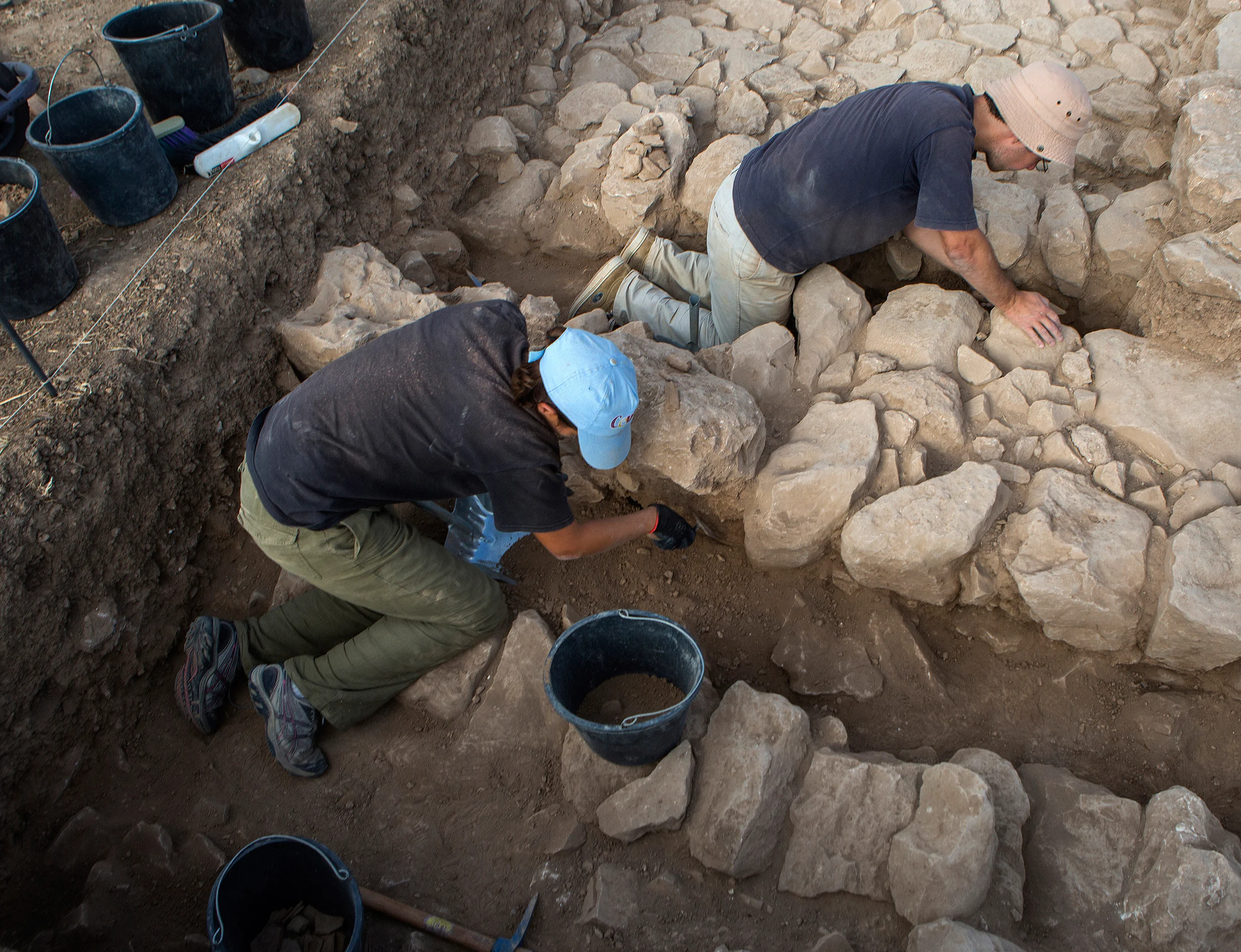
2017 campaign team. © José Pardo.
Survey A and excavated area by EBAF. © José G. Gómez.
Archaeological materials from survey A (Iron). © José Pardo.
The main work and results of the campaign were the following:
After 60 years of abandonment, Tell el-Far’a has suffered important transformations regarding its use. Nowadays, the site is divided into four private owners and the Palestinian administration. An important part of the private sector is used for agricultural activities, in particular, for the plantation of olive trees. Regretfully, the exploration of these extents limits considerably the archaeological research. The areas freed from agricultural work are situated in the eastern sector and, especially, in the western part of the tell. It was in the latter, a private property, that the French archaeologists concentrated their excavation work between 1946 and 1960. Therefore, this part of the site is the one that preserves the main archaeological remains still visible (houses, streets, wall, door, etc.). With the aim of recovering these constructions made in stone all the weeds and extant debris were gathered and collected, in order to establish the state of conservation, which, in general terms, is good. The final goal is to prepare a general plan to proceed to the restoration and valorisation in future interventions.
With the help of a drone a new plan of Tell el-Far’a was elaborated in order to understand the topographical evolution of the archaeological site between 1946 (year of the elaboration of the first plan by the French team) and today. Based on the drone flights we were able to establish a detailed plan of the tell as well as its surrounding environment, through the creation of a 3D model (orthophotoplan) and a conventional model with contour lines. In both cases, the different contemporary uses of the tell as well as the location of debris areas created by the EBAF excavations (which transformed the original morphology of the site, particularly in the occidental periphery) were detailed. To the achievement of this work, the analysis of aerial photographs taken in 1950 and presently preserved in the archive of EBAF’s mission in Jerusalem was of invaluable help.
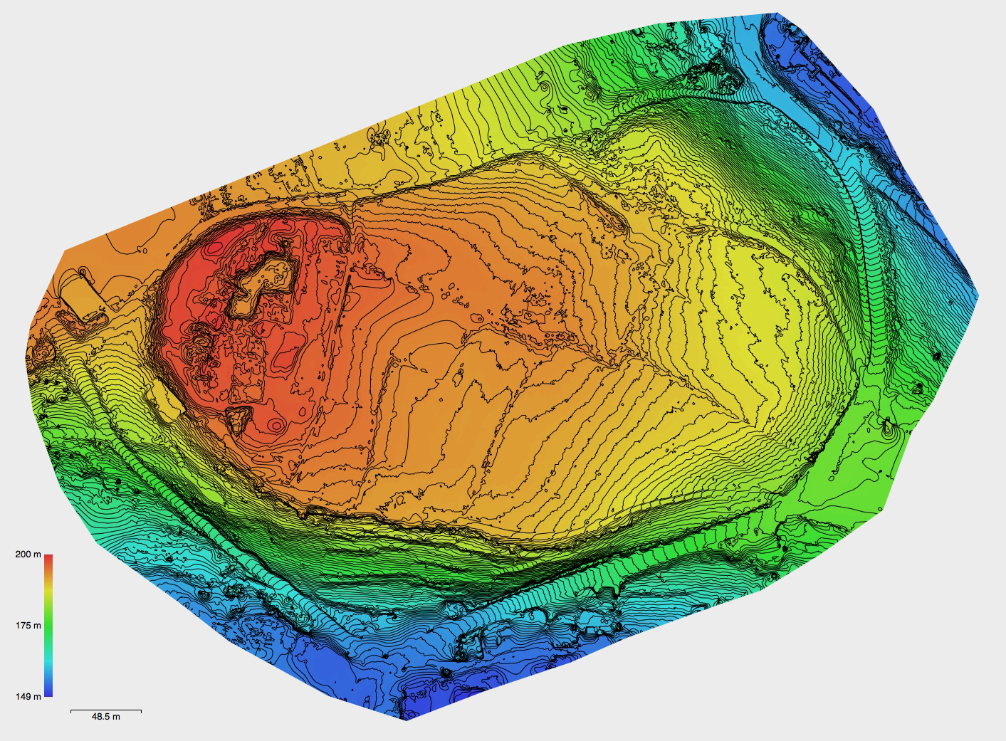
Topographic map of Tell el-Far’a, October 2017. © José Gabriel Gómez.
After the cleaning of the archaeological site, a superficial prospection of the tell and its meridional necropolis (dated to the Bronze Age) was carried out. In the first case, the visible archaeological remains (wall and houses mainly) were photographed and the areas susceptible of being excavated in the future were identified. In the second case, the necropolis situated in natural caverns in the mountain located on the other side of ‘Ain ad-Dlaid (south of the tell), it was only possible to confirm its looting and destruction.
An archaeological survey of 5 x 6 meters, denominated survey A, was made near the house excavated by De Vaux (loci 409B and 416) in the western sector of the tell. The purpose of this operation was the establishment of a chronological sequence for the Iron Age in Tell el-Far’a. The work developed allowed the provisory identification of up to three distinct phases of occupation, formed by various stone walls and floors. We were able to collect several samples of archaeological deposit and faunal bone remains to study its absolute dating (TL, OSL and C14) in laboratories of the University of A Coruna (Geochronology Unit) and of the CSIC-University of Seville (National Accelerator Centre).
During the excavation process, was recovered abundant ceramic material severely fragmented (abandonment phase). A selection of this material was drawn with the purpose of creating a typological table of the pottery characteristic of the Palestinian Iron Age. Of this material, samples were taken in order to analyze the geochemical composition and identify centres of pottery production (local, regional, super-regional, etc.) and possible trade routes. Finally, among the exhumed objects should be highlighted the small heads of quadrupedal figures made in terracotta.
Juan Luis Montero Fenollós (director)
Francisco Caramelo (director)
Jehad Yasin (director)
André Teixeira (archeologist)
Joana Bento Torres (draughtswoman)
José Pardo (photographer)
José Gabriel Gómez (topographer)
Sofyan Dois (archeologist)
Bassam Helmi (topographer)
Meher Hassan (topographer)
1-20 October 2017.
The archaeological project Tell el-Far’a wishes to express its gratitude to the Municipality of Wadi Far’a, the Camp of f Far’a, the Sports and Youth Centre of Far’a, the General Consulate of Spain in Jerusalem, and to École Biblique et Archéologique Française for their support and collaboration during the campaign.